


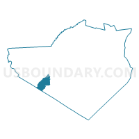
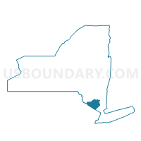
Voting District 110002 110004, Orange County, New York
About
Outline

Summary
| Unique Area Identifier | 633592 |
| Name | Voting District 110002 110004 |
| County | Orange County |
| State | New York |
| Area (square miles) | 12.19 |
| Land Area (square miles) | 12.11 |
| Water Area (square miles) | 0.08 |
| % of Land Area | 99.38 |
| % of Water Area | 0.62 |
| Latitude of the Internal Point | 41.32107880 |
| Longtitude of the Internal Point | -74.52352290 |
Maps

Graphs
Select a template below for downloading or customizing gragh for Voting District 110002 110004, Orange County, New York


Neighbors
Neighoring Voting District (by Name) Neighboring Voting District on the Map
- Voting District 110001, Orange County, NY
- Voting District 110003, Orange County, NY
- Voting District 210001, Orange County, NY
- Voting District 220001, Orange County, NY
- Voting District 220006, Orange County, NY
- Wantage township voting district 1, Sussex County, NJ
- Wantage township voting district 5, Sussex County, NJ
Top 10 Neighboring County Subdivision (by Population) Neighboring County Subdivision on the Map
- Warwick town, Orange County, NY (32,065)
- Wantage township, Sussex County, NJ (11,358)
- Wawayanda town, Orange County, NY (7,266)
- Minisink town, Orange County, NY (4,490)
Top 10 Neighboring Place (by Population) Neighboring Place on the Map
Top 10 Neighboring Elementary School District (by Population) Neighboring Elementary School District on the Map
Top 10 Neighboring Secondary School District (by Population) Neighboring Secondary School District on the Map
Top 10 Neighboring Unified School District (by Population) Neighboring Unified School District on the Map
- Warwick Valley Central School District, NY (23,647)
- Minisink Valley Central School District, NY (23,035)
Top 10 Neighboring State Legislative District Lower Chamber (by Population) Neighboring State Legislative District Lower Chamber on the Map
- General Assembly District 24, NJ (215,703)
- Assembly District 97, NY (144,514)
- Assembly District 98, NY (138,734)
Top 10 Neighboring State Legislative District Upper Chamber (by Population) Neighboring State Legislative District Upper Chamber on the Map
- State Senate District 38, NY (347,376)
- State Senate District 42, NY (313,027)
- State Senate District 24, NJ (215,703)
Top 10 Neighboring 111th Congressional District (by Population) Neighboring 111th Congressional District on the Map
Top 10 Neighboring Census Tract (by Population) Neighboring Census Tract on the Map
- Census Tract 118.01, Orange County, NY (4,592)
- Census Tract 117.02, Orange County, NY (4,490)
- Census Tract 145.01, Orange County, NY (4,432)
- Census Tract 3711, Sussex County, NJ (3,951)
- Census Tract 118.02, Orange County, NY (2,674)
Top 10 Neighboring 5-Digit ZIP Code Tabulation Area (by Population) Neighboring 5-Digit ZIP Code Tabulation Area on the Map
- 07461, NJ (19,563)
- 10958, NY (3,291)
- 10998, NY (3,122)
- 10973, NY (2,126)
- 10969, NY (1,267)
- 10988, NY (896)